5 space area targets instructions to make work space tracker
1. SDK Version: 6.1.0
2. Development Environment: Unity-Android, Unity-IOS
3. Tracker/Scanner: SpaceTracker
4. License Type(Free / Pro-One Time Fee / Pro-Subscription / Enterprise): Trial
In the latest update to your SDK (6.1.0) it's mentioned that it supports up to 5 space area targets instead of 1 on the previously version of the SDK.
In my particular case, I need to develop a navigation application for a museum that is larger than 20x20 square meters. This is a short animation about what I use it:
Animation museum navigation SpaceTracker
I've been trying to go further 20x20 with the new 5 space area targets but I've not able to create the solution. You provided me feedback before (instructions not working) but, even following your instructions, I wasn't able to create.
I was wondering if it's possible that you included a example in the SDK or even better a video tutorial showing how to do it. This feature is quite critical for me because it would allow me to pitch the project to bigger museums and that would allow me to buy more licences from you.
Thank you for your interest in MAXST AR SDK.
We understand that setting up packages is not easy.
We'll be updating the package in the future to make it easier to use, but in the meantime, please follow the steps below.
1. Only works with Maxscan 1.1.0 or later and AR SDK 6.1.0 or later.
2. The Maxscan app scans the space and moves the spatial maps to your PC.
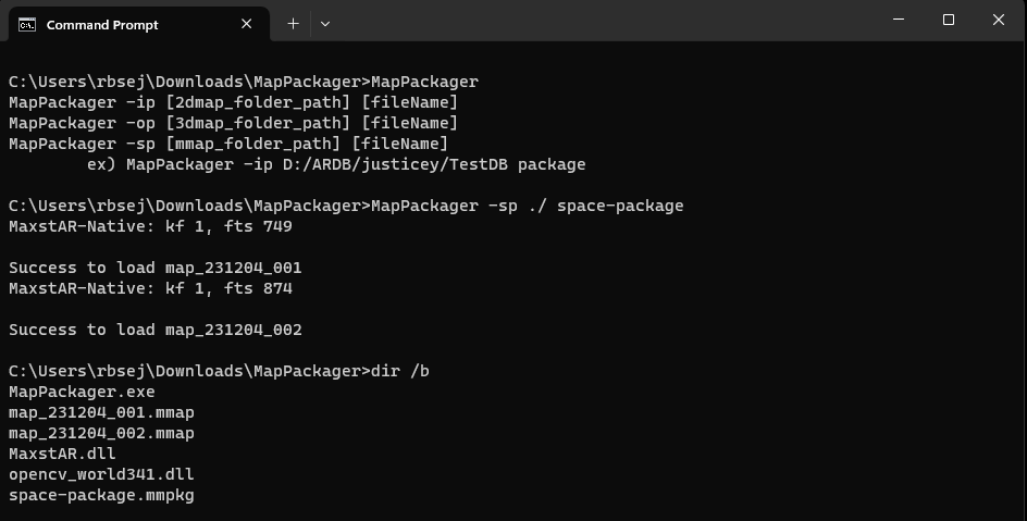
3. Download MapPackager from Download > Tools
4. Save your MMAP files under a specific folder.
5. Open a Command window, and navigate to the MapPakager folder.
6. Create an mmpkg. ex) MapPackager -sp D:/ARDB/justicey/TestDB package
7. Create a Unity project, download the AR SDK, and import it.
8. Save the spatial map data and package (mmpkg) file in StreamingAsset.
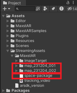
9. Drag the .obj file into the Inspector window and load it. (do not set mmap)
10. Place content using a spatial mesh.
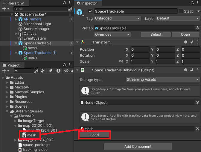
11. Replace the existing code in SpaceTrackerSample.cs > AddTrackerData() with the AddTrackerData() code in Space Tracker Sample > Set Package.
12. Enter the packagePath of the AddTrackerData() code.
ex) string packagePath = “Maxst/space-pakcage.mmpkg”
* Enter only the path under StreamingAssets.
13. Build and run.
If it doesn't work, please leave a reply.
Thank you.
Best regards,
Shelden
MAXST Support Team
Thanks for your support.
I have managed to follow your and run successfully the application with 2 targets. Unfortunately each space tracker is an independent target, so it's impossible to extend my navigation system because I cannot connect multiple scans into a bigger one.
To have independent targets makes sense for objects, so I understand your approach, but for my particular case where a want to use a navigation system in a big area to guide users your approach is not an option.
We're sorry we couldn't help you.
We'll take your comments into consideration and improve the Maxst AR SDK in the future, thank you.
Best regards,
Shelden
MAXST Support Team